• AMERICAN GEOSERVICES
  • Ph 888-276-4027
  • [email protected]
  • Welcome
  • PORTFOLIO
  • Services
    • Geotechnical Engineering >
      • Geotechnical Engineering
      • Soils Reports/Geotech
      • Slopes/Retaining Walls
      • Drainage/ Groundwater >
        • Surface Drainage
        • LTAR (Long Term Acceptance Rate)
      • Expansive Soils >
        • Fat Clays
      • Collapsible Soils
      • Pile Integrity Test
      • Soil Nailing
      • Slope Stability Analysis
      • Geotechnical Instrumentation & Monitoring
      • Groundwater Monitoring
      • Mining and Quarrying
      • Swimming Pool Structure
    • Geotechnical Explorations >
      • Geotechnical Explorations >
        • Soil Boring and Sampling
      • Geotechnical Site Investigations >
        • Geophysical Soil Exploration
      • Standard Penetration Test
      • Cone Penetration Testing
      • Dynamic Cone Penetration Testing
      • Piezocone Penetrometer
      • Seismic Piezocone Penetration Test
      • Soil Infiltration Testing
      • Inclinometers
    • FOUNDATION ENGINEERING >
      • FOUNDATION ENGINEERING
      • Foundations Types >
        • Machine Foundations
        • Floating Foundations
        • Strip & Pad Foundations
        • HUD Foundations
        • Sheet Piles
        • Drilled Shafts
        • Wind Turbine Foundations
        • Geosynthetic Reinforced Foundations
      • Earthquake Resistant Foundations
      • Foundation Repair >
        • URETEK GEOPOLYMER INJECTION
      • Proprietary Foundation Systems
      • Basement Extensions
      • Forensic Engineering of Foundations
      • Foundation Grouting
      • Construction in Cold Regions
      • Foundation Design For Shipping Container Homes
    • GEOLOGICAL ENGINEERING >
      • Geological Hazard Assesment
      • GEOLOGICAL ENGINEERING
      • Rockfall Hazards
      • Landslides
      • Liquefaction
      • Debris Flow
      • Sinkholes
      • EMBANKMENT OR FILL
    • Septic Engineering >
      • Septic System Feasibility
      • Septic System Design
      • Alternative Septic Systems >
        • Glendon Biofilters
        • Mound Systems
        • Sand Filter System
      • Septic Mound Systems
      • Percolation Testing
      • Percolation Testing
      • Site Evalution for Sewage Systems
    • PHASE I-III ASSESSMENTS
    • ENVIRONMENTAL ASSESSMENTS >
      • Environmental Impact Statement (EIS)
      • Spill Prevention, Control, and Countermeasure (SPCC) Plans
      • Fault Investigation
      • Clean Construction Demolition Debris Certification
    • Site-Specific Seismic Evaluations >
      • Site-Specific Seismic Hazard Evaluation
      • Seismic Site Class Determination
      • Shear Wave Velocity Measurements
      • Response Spectra Analysis
      • SHAKE Analysis
      • Liquefaction Hazard Evaluation
    • BUILDING ASSESSMENTS >
      • Property Condition Assessments
      • Commercial and Residential Building Inspections
      • STRUCTURAL INSPECTION
    • Retaining Walls
    • Shoring
    • Pin Piles
    • Gabion wall
    • HELICAL PIER
    • Structural Retrofitting
    • MANTA RAY ANCHORS
    • GEOPHYSICS
    • PAVEMENTS / PUBLIC WORKS >
      • FLEXIBLE PAVEMENTS
    • SOFTWARE >
      • Retainpro 10
      • Ultrablock walls
  • Contact Us
  • Employment
  • Library
  • Florida Geo Services
  • Blog
  • Landing 2024

geophysical soil exploration

What are geophysical soil exploration methods?
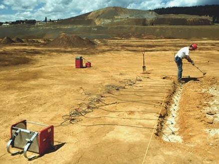
Geophysical methods, which are widely used in highway work and in other applications, can be implemented more quickly and less expensively and can cover greater areas more thoroughly. They tend, however, to yield less definitive results requiring more subjective interpretation by the user. Accordingly, a number of borings are still required to obtain soil samples from which accurate determinations of soil properties can be made in order to verify and complement results determined by geophysical methods. Two particular geophysical methods - seismic refraction and electrical resistivity - are most commonly used. In the former, resistance to flow of a seismic wave through soil is measured; in the latter, resistance of soil to movement of an electrical current is determined. Using values obtained therefrom, a specialist can interpret the depth to and thickness of different soil strata and estimate, with the aid of supplemental borings, some of the engineering properties of the subsurface material.
​
What is the electrical resistivity method of soil exploration?
The electrical resistivity method consists of measuring the resistivity of the soil strata and correlating the resis­tivity to the properties of the soil. The principal application of the electrical resistivity method is in investigating foundations of dams and other large structures, particularly in exploring granular river channel deposits or bed­rock surfaces. The method is also used for locating fresh or salt water boundaries.

The electrical resistivity method can be broken down into two types of testing, the 'electrical profiling method' and the 'electrical sounding method'.

How is the electrical profiling method of soil exploration performed?​
​In this method, four electrodes, usually in the form of metal spikes, are driven into the ground at the same spacing. The two outer electrodes are known as current electrodes, and the two inner electrodes are known as potential electrodes.
Picture
Picture
A direct current (DC) of 50-100 milliamperes (mA) is applied between the outer electrodes, and the voltage drop or the potential difference between the inner electrodes is measured using a poten­tiometer. The mean resistivity of the soil up to a depth of D cm below ground surface is obtained from the equation above, where D is the distance between electrodes in centimetres (cm), V the voltage drop between inner electrodes in volts (V), and I the current flowing between outer electrodes in amperes (A).

The electrodes are moved as a group, at the same spacing between them and different profile lines are run across the area. The test is repeated after changing the spacing to determine the mean resistivity up to a depth equal to the new spacing. The method is also known as resistivity mapping method. The type of soil or rock stratum encountered will be estimated using the measured resistivity from the table below.​
Picture
How is the seismic refraction method of soil exploration performed?
The seismic-refraction method is based on the principle that elastic shock waves travel at different velocities in different materials. Shock waves are generated at a point on the ground surface, using a sledge hammer. These waves travel deep into the ground and get refracted at the interface of two different materials and to the ground surface. The time of arrival of these waves at different locations on the ground surface are recorded by geophones, which pick up the refracted waves. The geophones convert the ground vibrations into electrical impulses and trans­mit them to a recording apparatus.

When the distance between the vibration source and the geophone is short, the arrival time will be that of a direct wave. When the distance exceeds a certain value (depending on the thickness of the stratum), the refracted wave will be the first to be detected by the geophone. This is because the refracted wave, although longer than the direct wave, passes through a stratum of higher density (and hence higher seismic velocity).
​
Knowing the time of travel of the primary and refracted waves at various geophones, tune and distance graphs are drawn based on which it is possible to evaluate the depth of various strata in the sub-soil. Different materials such as clay, gravel, silt rock, hard rock etc. have characteristics seismic velocities and hence it is possible to establish their identity in the sub-soil based on time distance graph.
​
Picture
Picture

​How is the electrical sounding method of soil exploration performed?

This method is similar to the electrical profiling method, except that the electrode system is expanded about a point P by increasing the spacing between the electrodes in successive operations, the electrode spacing is increased with every successive test, as shown in the figure below.
Picture
As the depth of current penetration is equal to the electrode spacing, the change in the mean resistivity is correlated to the changes in the strata at that location. The midpoint (P) moves forward by a distance of 4D in successive tests of the electrical profiling method. However, the midpoint (P) remains at the same position in the electrical sounding method.
​

The electrical resistivity method is found to be less reliable than the seismic-refraction method, since the resistivity of a particular soil or rock can vary over a wide range of values depending on the density, voids or fractures, and degree of saturation of the soil.
Picture
Picture

SERVICE AREAS & MAILING ADDRESSES 

COLORADO
Denver, CO
191 University Blvd #375 
Denver, CO 80206
(303) 325-3869
Dial Entire Number
​
Boulder, CO

2810 E. College Ave #102 
Boulder, CO 80303
(303) 325-3869
Dial Entire Nu
mber

​
Fort Collins, CO
​
1281 E Magnolia St D250, Fort Collins, CO 80524 
(303) 325-3869
Dial Entire Number
COLORADO
Colorado Springs, CO
3862 Hodgen Pond Ct Colorado Springs, CO 
(719) 571-9423
Dial Entire Number


Pueblo, CO
140 W. 29th St #311
Pueblo, CO 81008

(719) 571-9423​
Dial Entire Number

Glenwood Springs, CO
1338 Grand Avenue #316
Glenwood Springs, CO
(970) 436-7050

Dial Entire Number​​​

OREGON
Portland, OR
Salem, OR
Lincoln City, OR
Newport, OR
Eugene, OR
Bend, OR

6312 SW Capitol Hwy #231
Portland, OR 97239
(503) 922-3432
​Dial Entire Number
WASHINGTON
Seattle, WA
24 Roy Street #727
Seattle, WA 98109
(206) 418-6634
​Dial Entire Number

Vancouver, WA
Longview, WA
​41105 NE Cedar Ridge Rd
​Amboy, WA 98601
(360) 437-6369
Dial Entire Number​
​FLORIDA
Jacksonville, FL
6001 Argyle Forest Blvd,
Suite 21
Jacksonville, FL 32244

(904) 512-0085
Dial Entire Number

Orlando, FL
10524 Moss Park Rd,
Suite 204 #701

Orlando, FL 32832
(407) 362-1940
Dial Entire Number

FLORIDA
Tampa, FL
701 S Howard Ave #106, Tampa, FL 33606
(813) 569-7704
Dial Entire Number


​Miami, FL
3725 W. Flaglen St,
Miami, FL 33134
(305) 677-9494
​Dial Entire Number

Upcoming: INDIA

Pune, India
Bungalow 21, Acacia Garden 2 Magarpatta City, Hadapsar
India
Maharashtra
Pune
​411028


Copyright 2016 American GeoServices, LLC.  All rights reserved.